Prof Fred Hattermann of the Potsdam Institute for Climate Impact Research (PIK), together with adelphi consult GmbH, developed a set of scenarios of future water availability for rivers Juba and Shabelle under climate change conditions. The study was commissioned by the Ministry of Energy and Water Resources (MoEWR) of the Federal Government of Somalia. Together with Annika Kramer, I made a (very) modest contribution to this work.
A set of historic and recent global climate projections from the Coupled Model Intercomparison Project (CMIP) were statistically downscaled for a window in the Horn of Africa. They served as the input for the eco-hydrological SWIM model that was specifically adapted for the Juba and Shabelle basins to reflect their relevant terrain and environmental features.
The reader is referred to the “Technical report: Climate change impacts in the Juba and Shabelle Basins, Somalia; Modelling climate change impacts on water resources and hydrological extremes” for the detailed approach and findings.
Key Observations
The key observations of the study included:
- Under all future emission scenarios, temperatures are expected to increase in the Juba and Shabelle basins until the end of the century and probably beyond. The low-end range of regional temperature increase is 0.35°K-2.73°K, while for the high-end scenario it ranges from 1.16°K-6.25°K. Specifically the upper end of the SSP5-8.5 scenario represents a much warmer regional climate. In addition to the general increase in temperature, there is a high certainty that hot days and tropical nights will increase both in number and intensity.
- Projections for changes in precipitation are more diverse. Precipitation is expected to increase for most scenarios and for most areas. However, decreases have also been observed in high-end climate scenarios, especially in the western parts of the Juba catchment and in the south-west of Somalia.
- Still, a mean increase in precipitation is anticipated in the upstream parts of the Juba and Shabelle catchments; these areas produce most of the runoff in both rivers.
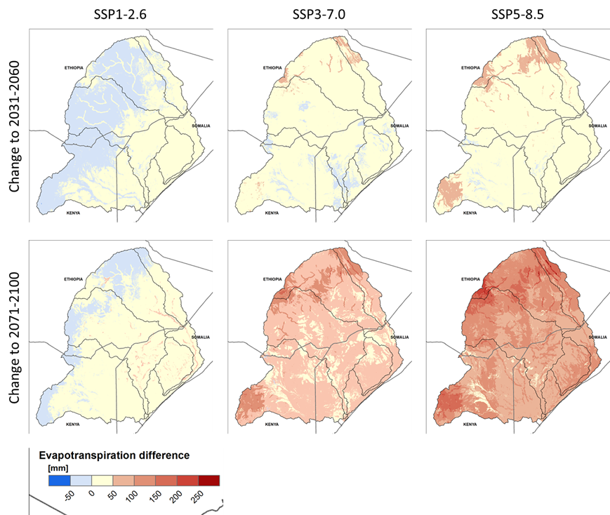
- The general increase in temperature and precipitation observed in the study results in more annual evapotranspiration in most of the Juba and Shabelle catchment area, in particular for the period 2071-2100.
- Only under SSP1-2.6 scenario conditions is a small decrease witnessed over a large area, mostly in the upstream parts of the catchment. This decrease becomes progressively smaller when approaching the horizon-year 2100.
- The projected increases in evapotranspiration by the horizon-year 2100 are particularly high in the riparian zones and wetlands.
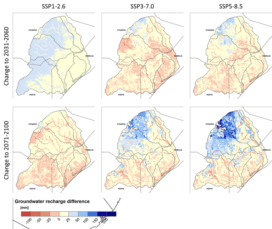
- A diverging direction of change in annual groundwater recharge is observed in the study area under different climate change scenarios. Recharge generally increases in the upstream parts of the catchments—and in areas further removed from riverbeds. The highest increase is observed in the most northern part of the catchment area, where river Shabelle originates.
- By contrast, except for a few upstream areas, groundwater recharge decreases in the respective riverbeds and riparian zones in all scenarios for the 2071-2100 timeframe.
- Mean annual discharge in the Juba basin may increase slightly until the end of the century under mid and high-end climate scenarios; however, no significant change in average annual flow was observed for low-end global warming scenarios.
- However, when selecting only dry projections, annual discharge may decrease in the downstream, Somalian parts of the basin.
- There are some indications that monthly discharge in the rainy season will increase in the Juba. By contrast, no or only very limited additional discharge is anticipated in the dry season. These results, however, are subject to high uncertainty.
- The average annual flow of the Shabelle at Beledweyne could increase by some 25-30% by the end of the century. Nevertheless, the range of the future flow regimes is very wide and future water resources availability is subject to high uncertainty.
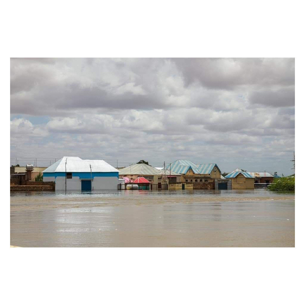
- There is a high degree of certainty about a significant increase in both the frequency and magnitude of extreme floods in the Juba and Shabelle basins. Future extreme floods will exceed historic flood events by a considerable margin.
What does it mean?
Each point in the above enumeration is elaborated in the text below.
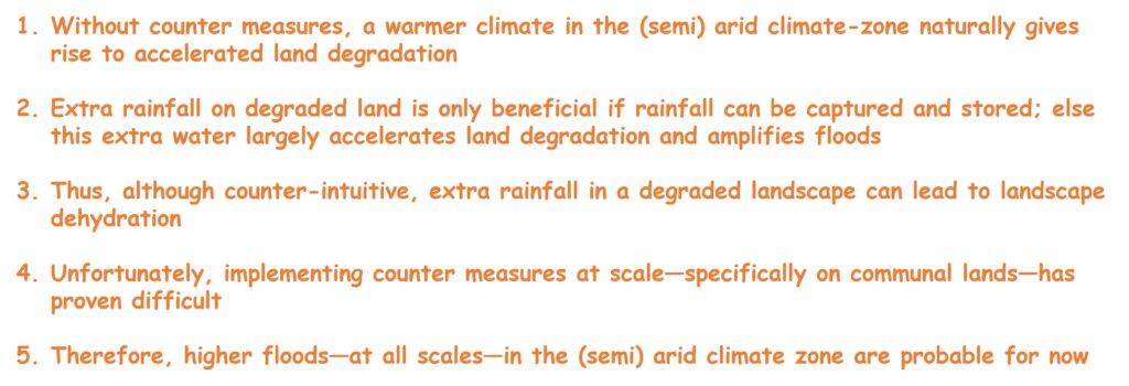
Point 1: a much warmer regional climate is ominous. Higher temperatures in the fragile drylands near the equator accelerate soil degradation and vegetation loss. This process is difficult to reverse. It also leads to more wind erosion (think ‘Dust Bowl’) while increasing drought risk. The latter is exacerbated by the high spatial and temporal variation of rainfall experienced in the Horn of Africa. It is a worrying scenario because “less vegetation leads to less vegetation”.
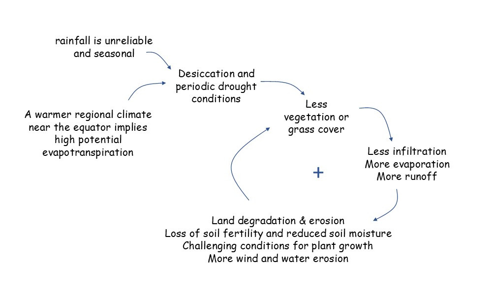
Point 2: while higher rainfall should be beneficial in principle, this is only when the extra rainfall can be used for productive purposes such as more vegetation, more infiltration, or more water storage. Achieving this is challenging in severely degraded landscapes and communal lands. Else the extra rainfall will just evaporate or, worse, will runoff while causing damage.
Point 3: extra rainfall in the absence of vegetation will amplify the rainfall-runoff response and increase the sediment transport capacity of gullies and streams. With an adequate slope, the channel will erode causing floodwater to concentrate and stop inundating the adjacent lands. Flood peaks will increase. In this scenario, groundwater and soil moisture are no longer replenished, and fertile sediments are no longer deposited. The incised channels will also lower the groundwater table and progressively dry-out the alluvial valleys. The above processes take place on all scales.
Point 4: proven land management practices exist that promote vegetation growth and/or infiltration. Many of these practices are concerned with small-scale decentralized and/or nature-based solutions. They focus on capturing and storing rainfall, and on slowing-down runoff. They exist for a wide range of farming and land management systems. Unfortunately, implementation at scale is difficult, specifically in communal areas. In addition, the required investments in land management are only warranted when (smallholder) agriculture is a viable economic proposition. Regretfully, this is often not the case.
Point 5: with less vegetation and less storage of rainfall in the landscape, larger parts of the catchment will contribute to direct (surface) runoff causing tributary floods with short concentration time and high peaks.
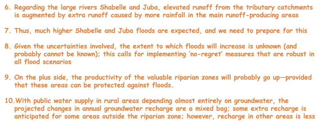
Point 6: the mean increase in precipitation anticipated in the upstream parts of the Juba and Shabelle catchments, which produce most of the runoff in both rivers, will increase flood volumes. The elevated runoff is further augmented by higher tributary floods (see point 5).
Point 7: the increase in flood extremes constitutes a robust signal in the climate scenarios. Flood risks will increase both in terms of frequency and magnitude of extreme floods. Extreme floods are predicted to exceed historic floods. It poses very significant risks for the densely populated and productive floodplains and riparian zones, and adequate mitigation and adaptation measures need to be taken.
Point 8: there are simply not enough data for a statistical flood analysis; besides, the principal drivers of flood events, such as extreme rainfall and the rainfall-runoff processes, are changing because of climate change and land degradation. Note that the impacts of these changes are non-linear, with many things happening ‘at the tail end of the distribution’ (i.e. at the extremes). Thus, we really do not know what future maximum flood volumes and levels will be.

Point 9: the productivity of the valuable riparian zones will likely go up, as illustrated by higher evapotranspiration in these belts observed in most model runs. This is caused by additional water availability for plants in the dry season, because of lateral inflow and because the riparian zone acts as water sinks. However, riparian zones can only be productive (for high-value activities) if periodic inundations are prevented. It puts a premium on flood control measures.
Point 10: public water supply in rural areas depends almost exclusively on groundwater. The anticipated changes in annual groundwater recharge are a mixed bag for the Somalian part of the Shabelle and Juba catchments. For the high-end scenarios, some extra recharge is anticipated in the 2071-2100 timeframe outside the riparian zone. For the low-end scenarios this is not the case. By contrast, groundwater recharge in the riparian areas is lower in all scenarios in the period 2071-2100.
Closing Comments
The risks associated with climate change in the Juba and Shabelle catchments are high while it will be difficult to capture the potential benefits. Challenges are mainly related to land degradation and floods. While proven measures exist to address these issues, they are difficult to implement on a large scale. Nevertheless, plenty of examples from other parts of the world have shown that it is possible to adapt to adverse climate and landscape conditions. I think that’s an integral part of the human story.
A video of the recent (Jul 2025) floods in Texas serves as a teaser of what we likely will be dealing with. Flood protection measures will probably involve a combination of zoning, responsible land management, nature-based-solutions, civil works, and early warning. In my view, none of these measures should be prioritized over the others. They all have a role to play.