
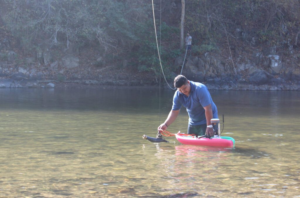
In January 2024, we conducted a workshop on ADCP flow measurement at Poso del Oso on Rio Lempa in El Salvador. The ADCP was a Sontek RS5. The training, however, was not only about how to use the instrument. Rather, it was primarily focused on producing defensible discharge data.
Defensible water data
Defensible discharge data are a component of defensible water data. The latter represents a new dimension in hydrography: how to prove—if necessary, in a court of law—that streamflow data are in fact correct and reliable.
The concept of defensible water data has been discussed in a previous post. It responds to an emerging environment in which water resources are increasingly scarce, where water allocation decisions are increasingly scrutinized, and where society is more litigious.
To avoid ‘disputed data’ in a litigious world, it is prudent to review—and whenever necessary adjust—the standard operating procedures to ensure that water data are defensible and will, if need be, stand up in court.
Note that defensible water data are the sum of many complementary parts. Every step in the data acquisition process matters. The weakest link will determine the accuracy and reliability of the data.
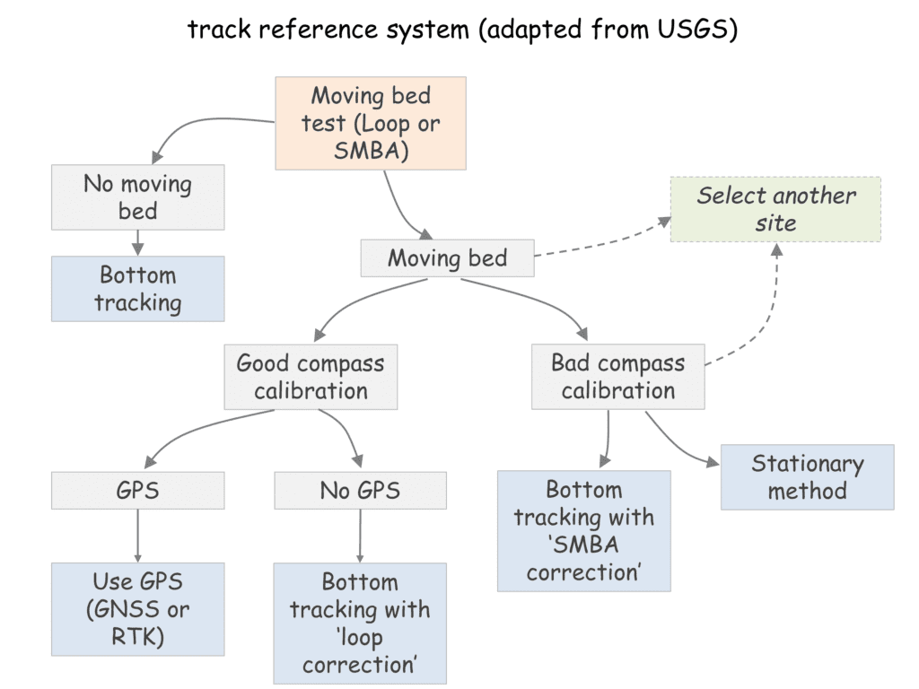
Measuring discharge is complicated. Even when using a sophisticated instrument such as an ADCP. The challenge is related to measuring the exact location of the ADCP when it crosses the river. This is reflected in the below schematic, which represents a well-established Standard Operating Procedure (SOP) for track referencing.
Standard Operating Procedures
Regarding discharge measurements, the concept of defensible water data will require the hydrographer to implement, verify, and archive every step in the above SOP, and submit the results for peer review or validation by a supervisor. The Sontek RS5—and similar ADCPs from other manufacturers—enables this QAQC process. For instance:
- Loop & SMBA tests will check for moving bed conditions; test results are kept together with the transect data in a single measurement file, which can be archived in a modern Water Data Management System for post-event validation and future referencing.
- The compass calibration log is stored in the same measurement file as mentioned above.
- Diverse information on the quality of the GPS signal is included in the transect file, which is included in the single measurement file (see above).
- The results of loop correction or the SMBA correction are included in the single measurement file.
- The results of a stationary measurement are stored in the single measurement file.
Thus, every step of the discharge measurement process is archived and can be validated (i.e. ‘defended’) at any time in the future. It enables a systematic quality control process ‘post-measurement’ and will therefore result in standardized procedures across the organization and eventually in more consistent and better data.
This contrasts with classic current meters. Here, no means exist to validate the measurement ‘post-event’. While in the field, each hydrographer makes his/her own assessment of the flow conditions and adjusts the measurement technique accordingly. Mistakes occur but are rarely noticed let alone corrected in a systematic manner. Paper measurement logs are reviewed, in principle, upon return to the office and then stored in an archive. They are rarely—if ever—looked at again. Only the final discharge data point is stored in an electronic database. There is substantial scope for measurement and data error.
The above discussion emphasizes the value of modern flow measurement equipment. Not only does it produce more accurate data, but it also produces electronic files of each step in the measurement process that can be reviewed post-measurement to validate the data point and improve the data acquisition processes across the organization. It represents a key step in producing defensible water data.
When to buy GPS RTK?
Instable riverbeds—referred to as ‘moving bed’—are a common feature of many rivers during high and flood flows. It introduces an error in the measurement of the exact location of the ADCP when the instrument is used in ‘bottom tracking mode’ and therefore underestimates discharge.
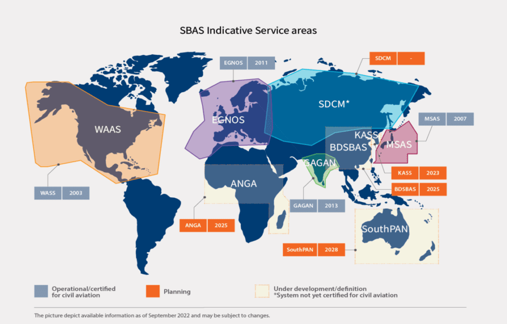
Modern ADCPs are therefore equipped with a GPS receiver. GPS signals, however, are subject to a measurement error—of a few meters—and can only be used for determining the precise position of the ADCP when corrected, preferably in real time. Satellite Based Augmentation Systems (SBAS) have been developed for this purpose in many parts of the world. It delivers sub-meter precision and is adequate for most rivers and most monitoring objectives.
SBAS are not available for the entire world (see image below). An alternative GPS correction is provided by Real-Time Kinematic (RTK) GPS technology. It delivers highly precise location information (error < 5 cm) but is very expensive. When is it essential?
Note that the ADCP can be employed in stationary mode and that two post-processing techniques exist to correct for moving bed conditions (loop correction and SMBA correction).
Some guidelines:
- RTK is necessary for large (and deep) rivers that are subject to significant moving bed, where the stationary method is in practice not feasible because of the width of the river and/or the absence of a good boat & boat driver, and where SBAS correction is not available.
- In smaller rivers (width < 50 m), the ADCP can be operated in stationary mode.
- In even smaller rivers (width < 25 m), loop correction or SMBA correction can be used, or the ADCP can be employed in stationary mode.
Hence alternatives to RTK do exist for many hydrometric conditions (when SBAS is not available). In case of budgetary constraints—thus, in most cases—there is a tradeoff between an ADCP setup with RTK, and several ADCPs without RTK. The best choice is a function of the size of the rivers that need to be monitored, the available equipment and skills, and the exact monitoring objectives.
Components of defensible water data
Defensible water data are the sum of many complementary parts. Every step in the data acquisition process matters. The weakest link will determine the accuracy and reliability of the data. Elements of defensible water data include:
- A discharge measurement process in which every step is archived (preferably in an electronic file) and can be validated (i.e. ‘defended’) at any time in the future.
- A rating curve based on the hydraulic conditions of the control section.
- A water data management system that maintains a full audit trail and stores all measurement files (including ADCP files).
- A hydrometric network consisting of carefully selected station locations, well-designed hydrometric stations (that include benchmarks), and equipped with modern hydrometric instruments with specifications that meet the monitoring objectives.
- Well established QAQC procedures for every step in the water data acquisition process.